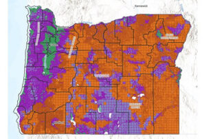
Senate Bill SB 80 was said to be course corrections to the admitted failure of the Wildfire Map required by SB 762. Changes included revising the map from Wildfire Risk to Wildfire Hazard. A change without distinction. At the same time the number of zones was reduced from five to three. The High and Extreme areas were combined to High. The Low and No Risk areas were combined to Low. Six open houses were required to be conducted as the revised law required robust public involvement to develop a final map and administrative rules for implementation.
In June 2024, six “open house” meetings were held around the state with a very brief overview of the revised program and people were encouraged to speak with representatives of the state agencies involved with the Wildfire Program. Maps were displayed that were not detailed to show taxlots so property owners could not see exactly what would happen to their property. On July 1, a more detailed draft map was released with an official 45 day comment period established. Over 2000 comments were submitted. Nearly all comments were opposed to the current and modifications to the Wildfire Program. The Forestry Board conducted a hearing and made no reference to the comments submitted. The Board directed staff to make some changes to the map because it was shown that irrigated lands reduced fires because of irrigation. The changes were only applied to lands classified as agricultural. The changes to the map reduced the number of high hazard parcels, state wide, from 104,521 parcels to 100,284 parcels.
SB 80 made a change in process to require appeals to be conducted as Contested Cases. This requires an Administrative Law Judge to review of appeals and conduct hearings. A schedule will be developed to hold hearings in person, by zoom, or phone. As a result of this change in appeal procedure, any property that is in a trust, business, partnership, corporation, or LLC must be represented by an attorney. An attorney may represent property owners that have the property in their own name.
A final map was created and a certified letter was sent January 7, 2025 to all property owners with land in a High Hazard Zone and located within a Wildland Urban Interface (WUI). A 60 day appeal period began on that date. Final administrative rules on Defensible Space and Home Hardening will be completed later in 2025. Appeal forms were included in the certified mailing to owners of High Hazard property that is also in the WUI. Appeal forms can also be accessed on the Oregon Department of Forestry website
https://www.oregon.gov/odf/fire/documents/wildfire-hazard-class-appeal-form.pdf