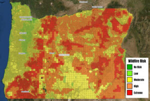
The primary piece of SB 762 is the adoption of the Wildfire Risk Map that has be delayed until 2023. The Risk Map places a designation on each property that is one of five classes.
These classes are 1) no risk, 2) low risk, 3) moderate risk, 4) high risk, and 5) extreme risk. In addition to the categories, the map shows what is called the Wildland-Urban Interface (WUI). This is an area where structures are located with a density of at least one structure per 40 acres. If your property is designated as high or extreme risk and you are in the WUI, you will be required to modify vegetation to reduce risk and new building codes will apply to make the building more resistant to fire damage. However, once you are in the high or extreme risk category, what you do to reduce fire risk will not change your risk category. There is nothing in the bill that provides a method to apply to have the designation reduced. There is one appeal period to ask for a change to your risk assignment based on mistakes but after the appeal period is complete there is no provision for change.
We do not see any basis in the bill that describes how the different classes are established and what would distinguish between each class. There is a numerical value that is calculated by computer programs that was shown on the home owners report that was available during the time that the Wildfire Risk Map was posted but that has been taken off the internet. There needs to be a better explanation on the mapping criteria, data sources and verification, and risk class distinction. The bill requires that the categories be based on weather, climate, topography and vegetation. When we asked questions about the data, sources and how risk classes were assigned we were directed to a Technical Guide that was prepared by Oregon State University that created the map is association with the Oregon Department of Forestry. From the technical guide, it is explained how computer programs were used to simulate burn probability and fire intensity and use the factors required in the bill. But no details are provided. A concern is that the information includes sizes of fires in the process to determine the amount of fire risk. With the “Let It Burn” policy in place, sizes of fires on federal land especially are much larger than necessary if fire suppression was applied to stop the fire at its smallest area. In the background report on Wildfires in Oregon, for each of the past three decades, 92-93% of all burned acres occurred on land outside ODF jurisdiction, namely federal land, which comprises 60% of forested land in Oregon.
The documentation that has been released on the map creation is located at:
https://www.orcities.org/application/files/7216/5911/0257/RiskMap_TechnicalGuide_062422.pdf
Background report is at:
https://www.oregon.gov/policies/Documents/FullWFCReport_2019.pdf