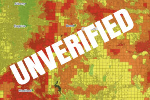
The Wildfire Risk Map was originally released in June of 2022 and after many complaints was withdrawn on August 4, 2022. The map is required to show five risk categories: no risk; low risk; moderated risk; high risk; and extreme risk.
Public and stakeholder engagement, outreach and education are scheduled from October 2022 to February 2023. This is said to include wildfire science, risk and mitigation outreach and education, with focus on the most vulnerable areas; identifying opportunities for investments in wildfire prevention; completing building codes and defensible space standards for the most vulnerable communities; compilation and analysis of feedback received; and technical refinements. Details of this outreach are not available at this time.
During this time, State Forestry and Oregon State University are revising the map for release of a draft map on March 1, 2023. There is to be a review period of the new proposal. This period is scheduled to be from March through September of 2023.
Oregon Department of Forestry (ODF) has released the following statements:
March through September 2023: Public outreach, engagement and education on draft wildfire risk map. Includes working with ODF, OSU College of Forestry, local governments, planning departments, Department of Land Conservation and Development, Oregon State Fire Marshal and the state Building Codes Division to review the draft map; public outreach, education and engagement on the draft map and related topics including building codes and defensible space standards; and making any necessary revisions based on feedback received on updated map.
October through December 2023: Final wildfire risk map shared with the public for implementation. Includes sharing a final wildfire risk map with the public, initiating a 60-day appeals process and notifying those who are in the most high-risk areas about the steps needed to protect their homes and properties from catastrophic wildfires and how to comply with defensible space standards and building codes.
Updates will be provided when available. The original map was developed by the Oregon State University using various computer programs to forecast wildfire intensity and occurrence probability. There was no ground verification of the required elements of slope and vegetation that are used with climate and weather to make risk conclusions. No additional information is available at this time on how the maps are to be revised.